 |
| Info | Register | Course | Photos | Directions | Results | FAQ |
| Driving Directions & Parking |
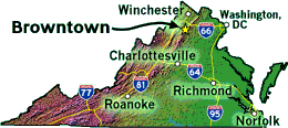
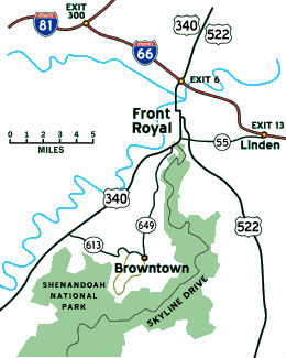
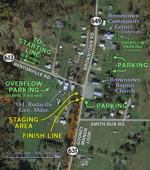
See the three maps at right for detailed views of the area, and scroll down this page for detailed driving directions and links to online maps! Registration location Our registration tables will be set up either outside near the finish line or under the outdoor picnic pavilion at the Browntown Community Center, depending on the weather on race day. We expect to have portable toilets set up outside the community center once again for runner use. Parking Our parking options are somewhat limited by the small size of Browntown, but we will have a few specific areas designated for parking on race day (shown on the map of Browntown at lower right). As we've done over the past few years, we'll place yellow "PARKING" signs in front of these areas, and we hope to have at least a couple intrepid volunteers directing you as to where to park. Your cooperation with our parking volunteers will be greatly appreciated! E-mail us if you'd be willing to be one of these volunteers. (We'll also have a few "NO PARKING" signs placed in certain spots, so that nobody parks where they're not supposed Maps & directions Online maps of Browntown can be found via...
While the specific driving directions provided below are quite detailed, getting to Browntown is actually not that difficult. For most of you, it'll involve hooking up with Route 340, following 340 to/through Front Royal, turning onto Route 649 (Browntown Road), and following 649 for 7.6 miles to Browntown. It's just that simple! (Folks coming from the southwest will take Route 340 to Bentonville and follow Route 613 [Bentonville Road] for 5.6 miles to Browntown.) Note: Routes 649 and 613 are winding two-lane roads with many hills and curves. Some sections can be prone to foggy conditions in the early morning hours. Deer, bears, and other animals cross the road with some frequency. Please drive carefully and don't speed! (To emphasize the point: While driving home from pre-marking the course a couple days before the 2012 race, the race director just barely missed hitting a deer that leaped out in front of his car with no warning.) Here are detailed driving directions to Browntown from various locations in the Virginia, Maryland, and DC region: From Winchester & points north: Take I-81 south to exit 300 (left exit) and get on I-66 eastbound. In 6.5 miles, take exit 6 (Front Royal, Routes 340/522), bear right off the exit ramp, and follow Route 340 south into Front Royal. In 1.8 miles, turn left at a stoplight (onto W. 14th St.) to continue following Route 340 southbound. In 0.2 miles, the road will curve sharply to the right and become Royal Avenue (still Route 340!). Get in the right lane, and in 0.4 miles, continue straight through a stoplight to stay on Royal Avenue/Route 340. Keep going straight for another 1.8 miles through Front Royal, eventually leaving town and passing the entrance to Shenandoah National Park & Skyline Drive. Take the next left (at a stoplight about a quarter mile past Skyline Drive) onto Route 649 (Browntown Road), and follow Route 649 for 7.6 miles to Browntown. From Berryville, Charles Town, & points northeast: Follow Route 340 south towards Front Royal. After going about 11 miles beyond Berryville, turn left at a stoplight at Double Tollgate (across from Dinosaur Land) to continue following Route 340 south. In 7½ miles, you'll pass under I-66. 1.9 miles beyond that, turn left at a stoplight (onto W. 14th St.) to continue following Route 340 southbound. In 0.2 miles, the road will curve sharply to the right and become Royal Avenue (still Route 340!). Get in the right lane, and in 0.4 miles, continue straight through a stoplight to stay on Royal Avenue/Route 340. Keep going straight for another 1.8 miles through Front Royal, eventually leaving town and passing the entrance to Shenandoah National Park & Skyline Drive. Take the next left (at a stoplight about a quarter mile past Skyline Drive) onto Route 649 (Browntown Road), and follow Route 649 for 7.6 miles to Browntown. From Leesburg & northern Loudoun County: Take Route 7 west towards Winchester. Exit at Berryville to follow Route 340 south, then follow the "From Berryville" directions above. From Manassas, Fairfax, Washington, & points east: Follow I-66 west to exit 13 (Linden, Routes 79/55). At the bottom of the exit ramp, turn left, then at the next stoplight in 0.2 miles, turn right onto Route 55 west. Follow Route 55 for 5.3 miles into Front Royal (past Burger King, McDonald's, Spelunker's, etc.). Eventually Route 55 comes to a "T" intersection at Route 340. Turn left at the stoplight onto Route 340 south and follow it for about half a mile. After passing the entrance to Shenandoah National Park & Skyline Drive, take the next left (at a stoplight just over a blind hill) onto Route 649 (Browntown Road). Follow Route 649 for 7.6 miles to Browntown. From Luray & the southern Page Valley: Head north on Route 340 for about 14½ miles to Bentonville, and turn right onto Route 613 (Bentonville Road). Follow Route 613 for 5.6 miles to Browntown, where the road comes to a "T" intersection at Route 649 (Browntown Road), just past O.J. Rudacille's store. The Baptist Church parking lot will be directly in front of you, or you can turn left to park in the smaller lot on the right-hand side (a couple hundred feet after the turn). From Harrisonburg, New Market, and the southern I-81 corridor: Take I-81 to exit 264 (New Market, Route 211) and follow Route 211 east for 14.6 miles. About two miles beyond Luray Caverns, exit off of the Route 211 bypass onto Route 340 north. Follow Route 340 north for 13.8 miles to Bentonville, and turn right onto Route 613 (Bentonville Road). Continue on Route 613 for 5.6 miles to Browntown, where the road comes to a "T" intersection at Route 649 (Browntown Road), just past O.J. Rudacille's store. The Baptist Church parking lot will be directly in front of you, or you can turn left to park in the smaller lot on the right-hand side (a couple hundred feet after the turn). From Culpeper, Sperryville, & Rappahannock County: From Culpeper, follow Route 522 north to Sperryville. From Sperryville, continue north on Route 522 for 8.1 miles, then turn left at Massies Corner to keep heading north on Route 522 towards Front Royal for another 14½ miles. Upon reaching Front Royal, turn left at a stoplight onto Route 55 west (there's a KFC on the near right corner). Follow Route 55 for 0.6 miles to a "T" intersection and turn left at the stoplight onto Route 340 south. After passing the entrance to Shenandoah National Park & Skyline Drive in about half a mile, take the next left (at a new stoplight) onto Route 649 (Browntown Road). Follow Route 649 for 7.6 miles to Browntown. How far is Browntown from...?
(Disclaimer: The mileages and drive times listed above are rough estimates. Your results If you are left with any questions about where Browntown is or how to get there, just send an e-mail to co-race director/Greasy-Gooney 10K cartographer Karsten Brown! Other things to do in & around Browntown Planning on spending the day or weekend out here in Warren County? There's plenty of stuff to see & do around here! NEARBY EVENT ON RACE DAY THIS YEAR: The final day of the Browntown Community Center Fall Yard Sale falls on our race date this year! So please, stop in before or after the race and have a look at what's left; the yard sale will be going from 8 AM to 2 PM. The other days of the Fall Yard Sale are Friday 10/17, Saturday 10/18, and Friday 10/23, from 8 to 2 each day. Shenandoah National Park is the most obvious nearby destination, although everybody else in the mid-Atlantic will have the same idea on our race weekend, so you'll have a long wait at the Front Royal park entrance unless you visit very early in the morning. The SNP entrance fee is currently $30 per vehicle for a 7-day pass or $55 for a 12-month pass; we recommend buying a park pass online in advance, as you may be able to enter the park more quickly if you already have a pass. If you're looking for tips on visiting Shenandoah National Park, the SNP web site has a great deal of info on things to do, and they have a smartphone app as well! Check out the web version of the late Henry Heatwole's old "Guide to Shenandoah National Park & Skyline Drive" for a deeper dive into the park, the overlooks along the Drive, and the park's many miles of trails. And the Potomac Appalachian Trail Club (PATC) offers an outstanding selection of maps, guides, and books related to SNP! (Many of the PATC maps & guides can be picked up at Royal Oak Bookshop at 207 South Royal Avenue in Front Royal.) Among other destinations in the area are Skyline Caverns just south of Front Royal, Shenandoah River State Park (9 miles south of Front Royal), Luray Caverns down in Luray (about half an hour south of Front Royal), and Cedar Creek & Belle Grove National Historical Park around Middletown & Strasburg (northwest of Front Royal). For you wine weirdos, Glen Manor Vineyards, located just a couple miles north of Browntown, is open from Wednesdays through Sundays, and there are about a million vineyards just over on the other side of the Blue Ridge in Rappahannock County. For many more ideas on things to check out and shops/restaurants to visit, head on over to the tourism web sites for Front Royal (to our north) and Luray/Page County (to our south)! |
| Info | Register | Course | Photos | Directions | Results | FAQ |
| The Greasy-Gooney 10K Web pages are maintained by Karsten Brown. |