 |
| Info | Register | Course | Photos | Directions | Results | FAQ |
| Course Information |
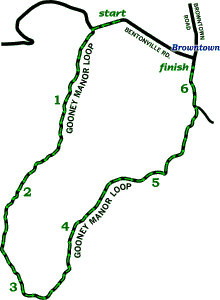
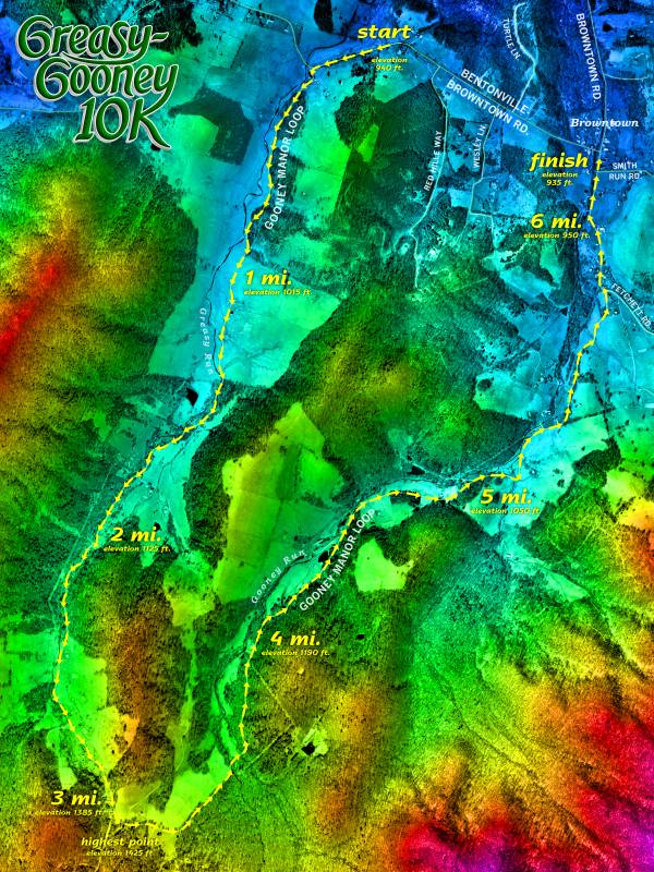
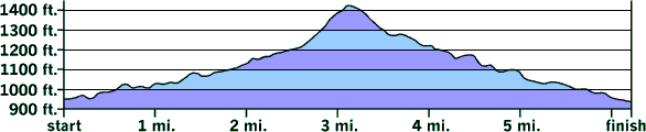
While the Greasy-Gooney 10K is quite scenic (go to the course photos page to see for yourself!), it is also somewhat challenging. The "U"-shaped course starts on Bentonville Road (Route 613) and quickly turns onto a quiet little road called the Gooney Manor Loop (Route 631). This road heads south up the Greasy Run valley for around three miles, gaining about 480 feet in elevation. Then the Gooney Manor Loop curves back around to the northeast and comes down the Gooney Run valley all the way to Browntown, losing about 500 feet in elevation. So in other words, it's uphill for the first half and downhill for the second half! Certification & measurement The Greasy-Gooney 10K course was certified for USA Track & Field by Neal Riemenschneider on 11 August 1999. The cerification number is VA99025RT. (Due to USATF rules instituted after our course was measured, technically our course's certification has "expired", but our route is unchanged from our first running in 1999. We are planning to remeasure this fall and have it recertified! ) Surfaces The course is 100% paved. Prior to 2013, a large portion of the Gooney Manor Loop (from the quarter mile mark to about mile 3.9) had been gravel, but for some reason VDOT decided to pave the entire loop that summer. The improved footing makes for a slightly faster course than before, although the road is still just as narrow, winding, and hilly as it's always been. Turns It is nearly impossible to get lost on the Greasy-Gooney 10K course, as there is only one real turn. This turn (a left) comes a mere quarter mile into the race, so after that, just keep going straight all the way back to Browntown! (There is a second semi-turn at mile 5.8; you'll encounter a stop sign where Fetchett Road [Route 632] comes in from the right. Just bear left here to continue on the Gooney Manor Loop [Rt. 631].) Water stops We expect to have a minimum of one water stop, located at the high point on the course near the halfway mark. (If we end up with enough volunteers on race day and/or if the weather is unusually warm or humid, we'll instead try to have two water stops, located at miles 2.1 and 4.) Mile marks Miles 1 through 6 will be marked with our usual blue & yellow signs stuck into the tops of traffic cones. Each intermediate half-mile will be marked with a little orange surveyor's flag or two. Elevation profile As mentioned above and as illustrated below, the course is basically 3.1 miles up and 3.1 miles down. But don't
Note to GPS users: If you wear a GPS watch or use a smartphone running app during the race, it may tell you that the course is long. If it does, your device is incorrect. Particularly with watches worn on the wrist or with less-accurate phone GPS, and when used at faster paces and/or under tree cover, GPS devices have a tendency to record inaccurate data points, and they invariably end up measuring long. Companies like Garmin do not sufficiently explain the limitations of GPS devices to consumers, and many GPS users place too much faith in the numbers their watches and smartphones give them, as if the devices work by magic. As a result, race directors have been hearing a lot of unjustified complaints about allegedly long courses ever since these devices came on the market. Any measurement by a GPS watch or smartphone should be considered nothing more than a ballpark estimate with a large margin of error, unless you can verify the recorded data points through some other means. Please be assured that despite whatever your GPS device winds up saying on race day, our 10K course has been measured to USA Track & Field's standards and is as close to 6 miles 1128 feet 4.787 inches as we can get it! And our mile marks have been carefully measured as well. Strava segments If you're a Strava user, you'll find four Greasy-Gooney segments on Strava! There's one for the entire course, one for the first (uphill) 5K, one for the last (downhill) 5K, and one for the steepest climb in the 3rd mile. MapMyRun The 10K route can now also be viewed on MapMyRun, although be aware that the elevation profile and mile markers they are showing are inexplicably rather inaccurate.
|
| Info | Register | Course | Photos | Directions | Results | FAQ |
| The Greasy-Gooney 10K Web pages are maintained by Karsten Brown. |